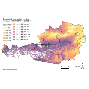
Austria has a wide variety of climatic conditions within a small area: there are numerous valleys and different altitudes, meaning that snow loads can vary considerably within a small radius. ÖNORM B 1991-1-3 therefore refers to the snow load map created by GeoSphere Austria (Austria's national agency for weather, climate, and geodata), which is available free of charge at hora.gv.at.
“For the new snow load map, we analysed the daily quality-checked snow data from the last decades for 900 measuring stations using the latest methods of extreme value statistics and converted it into a very detailed terrain model,” says Alexander Radlherr from GeoSphere Austria. “This enables location-specific estimates of snow load up to 2,000 metres above sea level and, in terms of detail, is one of the best products of its kind in Europe.”
This cooperation ensures that standards can reliably reflect and anticipate dynamic developments. "The example of extreme weather conditions clearly shows how crucial standards are: they translate safety into clearly defined, reliable rules that are tailored precisely to Austria. Standardization not only means uniformity, but also protects human lives, buildings and economic values by creating an objective basis for decision-making – especially in times of increasing extreme weather. Those who rely on these standards not only make more precise decisions, but also significantly safer ones," says Valerie Höllinger, CEO of Austrian Standards.
Austrian Standards has published a press release on this topic to illustrate the comprehensive impact of standards using a current example.