As unmanned aircraft systems (UAS), commonly known as drones, become more common in European skies, a question arises: how can we ensure that these aircraft remain within authorized areas and can be brought safely to the ground when something goes wrong? This matters especially near airports, restricted zones and densely populated areas, where an unexpected flight path may endanger people.
Three European Standards—EN 4709-003:2026, EN 4709-005:2026 and EN 4709-006:2026—address this challenge. Developed by CEN/TC 471 ‘Unmanned Aircraft Systems’, they offer complementary requirements and verification methods, from anticipating airspace infringement to containing an aircraft and, as a last resort, terminating its flight.
Knowing where a drone may fly
EN 4709-003:2026 focuses on geo-awareness, enabling the UAS to identify geographical restrictions and alert the remote pilot before the aircraft enters an area where its flight may not be authorized. These restrictions can have horizontal boundaries, altitude limits and time-related conditions. Its effectiveness depends on accurate geographical data and reliable positioning.
The standard specifies how geographical-zone information is loaded, how warnings are presented and how their timing is verified. A warning must arrive sufficiently early to allow corrective action, taking account of the aircraft’s speed and the distance needed to manoeuvre.
The document also addresses optional geofencing. Unlike geo-awareness, which informs the pilot, geofencing can automatically modify the flight path to prevent entry into restricted airspace. Importantly, the remote pilot must still be able to intervene, for example where an automated manoeuvre could create another hazard.
Keeping the aircraft within its authorized area
EN 4709-005:2026 introduces a complementary concept: geocaging. Rather than concentrating on an area the drone must avoid, geocaging defines the three-dimensional space within which the aircraft is expected to remain, in other words the containment volume. The standard addresses static geocaging, particularly for Class C6 systems.
It distinguishes the flight geography, where normal operations take place, from a surrounding contingency volume, where corrective manoeuvres can be performed. Together these form the operational volume, which establishes the outer limit of the authorized mission.
Before take-off, the relevant boundaries must be correctly programmed. The system must reject inappropriate flight plans, including routes or landing positions outside the defined flight geography. Once airborne, it monitors whether the drone remains inside those boundaries.
If the aircraft leaves its normal flight geography, an automatic contingency procedure is initiated, accompanied by an alert to the pilot. The aim is to return the drone to its planned area while keeping it inside the wider operational volume. If that outer boundary is breached, the system must automatically trigger flight termination.
This approach recognizes that preventing every deviation may be impossible. Safety also depends on anticipating what happens after a deviation and providing sufficient space for corrective action.
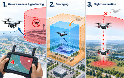 This image has been developed with the assistance of AI tools
When the flight must end
EN 4709-006:2026 addresses the final layer of protection: the Flight Termination System (FTS). Applicable to relevant Class C5 and C6 aircraft, it establishes requirements for ending a flight when continued operation would create an unacceptable risk.
Termination may be initiated manually by the remote pilot or automatically, depending on the system design. Once triggered, the procedure must operate predictably without requiring further pilot intervention and must prevent continued powered horizontal flight.
Attention is given to the independence of this emergency function. A malfunction affecting normal guidance or control must not necessarily disable the very mechanism intended to stop the aircraft. The standard therefore addresses the architecture and segregation of relevant systems.
Crucially, flight termination does not always mean an ordinary, damage-free landing. Its purpose is to limit the consequences of a hazardous flight. The standard requires manufacturers to assess how far an aircraft may travel before reaching the ground, considering height, wind, reaction time and positioning uncertainty. This information supports the determination of a suitable ground risk buffer.
A common safety objective
Taken together, the three standards establish a progressive approach: first, warn the pilot of a possible infringement; then, automatically contain the aircraft within its operational boundaries; and finally, terminate the flight when those boundaries can no longer be respected.
Their common strength lies in verification. Defined tests assess warnings, boundary approaches, contingency manoeuvres, pilot intervention and termination performance. Manufacturers must also provide clear instructions describing limitations and expected aircraft behaviour.
These functions help reduce the risk of airspace infringements and their consequences. They do not, however, constitute a complete system for detecting and avoiding other aircraft: a drone can remain inside its authorized area and still encounter traffic.
By translating safety objectives into measurable technical requirements, CEN/TC 471 contributes to more predictable drone operations and provides manufacturers and operators with practical tools for managing failures. The ability to know where an aircraft may fly, keep it within those limits, and end a hazardous flight will remain central to public confidence.
Thierry LEGRAND
tlegrand@cencenelec.eu


